State flag of South Africa.
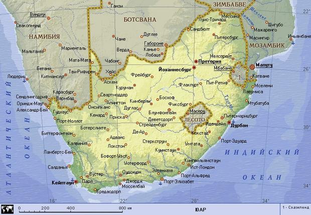
The Republic of South Africa - a state in South Africa, occupies a territory (1221 thousand square kilometers) in the extreme south of the African continent, in the west it is washed by the Atlantic, in the south and east - by the Indian Ocean. In South Africa is the southernmost tip of Africa - Cape Agulhas. The territory of South Africa in ancient times was inhabited by Bushmen, Hottentots and Bantu peoples, but after the discovery in 1488 by the Portuguese of the southern tip of Africa, colonization of the country began. In 1652, the first European settlement was founded by the Dutch East India Company. The history of South Africa is marked not only by the conquest of territory by aliens, but also by a fierce struggle (especially after the discovery of diamond deposits) between the descendants of the Dutch settlers, who formed a special ethnic community - the Boers, and England. The struggle ended with the formation on the basis of two Boer republics in 1910 of the Union of South Africa (since 1961 - the Republic of South Africa) as part of the British Commonwealth. The official languages are Afrikaans and English. The country's capital is Pretoria. Large cities - Port Elizabeth, Bloemfontein, Petersburg, East London.
Nature
South Africa is distinguished by its diverse nature. The surface is, as it were, a giant amphitheater: its highest part is formed in the east and south by a ledge of the Drakens and Cape Mountains, and to the north the surface descends in steps-plateau to a vast arena - the Kalahari and the valley of the river. Limpopo. The inner elevated plateaus and plains are bordered by a narrow strip of coastal oceanic lowland. Most of the surface is raised above sea level by 1000 m or more. Plain plateaus predominate: in the west the Small, Big and Upper Karoo, in the east the plateaus are called velds - High, Middle, Low, Shrub Veld. The internal plateaus and coastal plains differ sharply in natural conditions and are separated by the Great Ledge, steep from the coast, especially in the southeast and east. Here it is known as the Dragon Mountains (the highest point is Katkin Peak, 3660 m). In the southwest, the lower (1500-2000 m) Cape Mountains adjoin the Great Escarpment. From the side of the coast, the mountains are impassable, with narrow river valleys. The internal plateaus, also crossed by small remnant mountains (Kuruman, Langeberge) north of the middle reaches of the river. Orange pass into the Kalahari plain, crossed by dry riverbeds for most of the year.
Thus, the territory of the country covers several climatic zones: high mountain peaks and wide grassy plains, uneven coastal regions and flat, almost waterless landscapes of stunning inland spaces, shrub-covered steppes and eye-pleasing hills and valleys of the south - in general, each part of the country has its own, unique character.
The climate is predominantly tropical in the north and subtropical in the south. On the plateaus, the average monthly temperatures range from 7-10°C to 18-27°C, the most precipitation falls in the east - 1000-2000 mm per year, the least - on the Atlantic coast (less than 100 mm per year). The dry season is in winter (May-September). The main rivers are the Orange (with a tributary of the Vaal) and the Limpopo (on the border with Botswana and Zimbabwe).
The vegetation is just as varied. The flora includes 16 thousand species, the flora of the Cape floristic region in the south-west of the country (Cape Town region) is especially rich - 6 thousand species of plants, most of which are endemic. There are many different types of lilies, irises, poppies, heather, aloes, etc. In some places, a silver tree (of the Proteaceae family) has been preserved, the flower of which has become the national symbol of South Africa. Less than 2% of the country's territory is currently occupied by forests. Small forest areas with Cape boxwood, Cape mahogany, ironwood, as well as podocarpus and a number of other species have been preserved on the southern and eastern coasts. Much of it is covered in savannas, with palms and baobabs in Zululand, park trees in the Low Weld, and acacia and milkweeds in the Shrub Weld. The Kalahari and Karoo are dominated by deserted savannahs (with aloes, spurges) and deserts (Karoo). The fauna in its original state has been preserved only in reserves and national parks. The Kruger National Park is inhabited by lions, leopards, elephants, giraffes, hippos, buffaloes, antelopes, monkeys, many rare bird species, an aardvark that feeds on termites (there are 150 species of them in southern Africa). There are numerous rhinos (including white ones, which have become a rarity), buffaloes, hippos, crocodiles in the Hluhluwe reserve, and various waterfowl and near-water birds (pelicans, flamingos, herons, etc.) along the lake shores. Antelopes are diverse in the Kalahari-Hemsbok (more than 20 species). There is a special snake park in Port Elizabeth.
National Features
The population of South Africa is 44 million people and is a combination of people of different races, cultures, religions, speaking different languages and having an excellent social status. South Africa is the only country in Africa where a significant part of the population is made up of ethnic Europeans (Boers and British). Two-thirds of the population are peoples who speak Bantu languages, the most important of which are Zulu, Xhosa and Swazi. There are also Bushmen and Hottentots. The cultural traditions of South Africa are diverse. The most important ancient monument of the creativity of the South African peoples is rock art created by the Bushmen (images of animals and people were found in the Dragon Mountains). Even more ancient petroglyphs carved on stones along the banks of the rivers in the Transvaal and in the north of the Cape province and depicting elephants, antelopes, and less often - hunting scenes. From ancient times, the traditional occupation of the Bantu was cattle breeding and hoe farming, the Bushmen and Hottentots - mainly hunting, but in recent decades, the economy and life have changed markedly.
Johannesburg
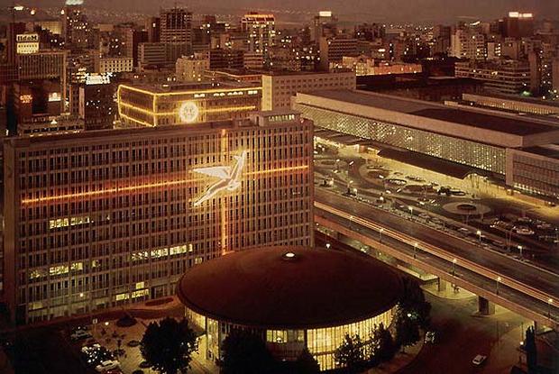
High-rise complex in Johannesburg.
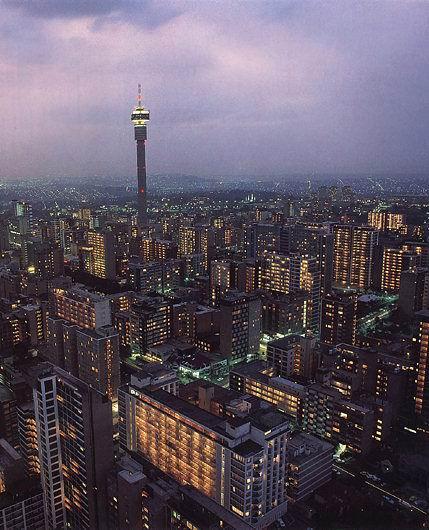
Johannesburg is the largest city in South Africa and the industrial and financial center of a country that is painfully but with great promise emerging from the darkness of the apartheid era. Johannesburg owes its appearance to gold, or rather, the Witwaterstrand Reef, discovered in 1886 by a traveling Australian gold digger and becoming the richest source of this precious metal in terms of its resources. Mines still enrich the country, but their importance has not been so great lately.
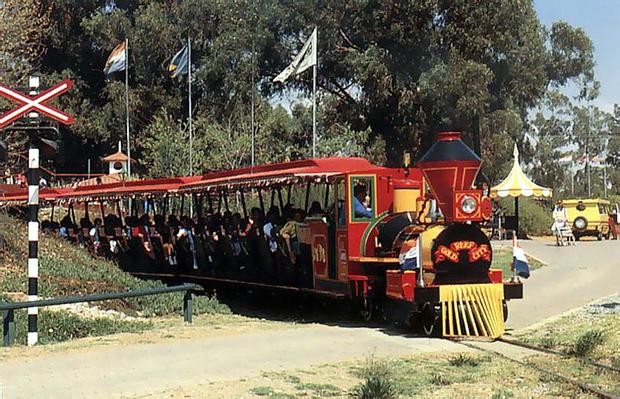
A train ride to Gold Reef City, an open-air museum that recreates the look of Johannesburg in the early 20th century.
Six kilometers from the center of Johannesburg is Gold Reef City, built on the site of the Crown Mines. It is a reconstruction of Johannesburg as it was during the time of its first inhabitants. Gold Reef City not only allows you to look into the past of the country, but also represents a real city of entertainment. By paying a small entrance fee, you can visit a variety of attractions, see street concerts, become a spectator of dancers performing national dances and even see with your own eyes how gold bars are cast.
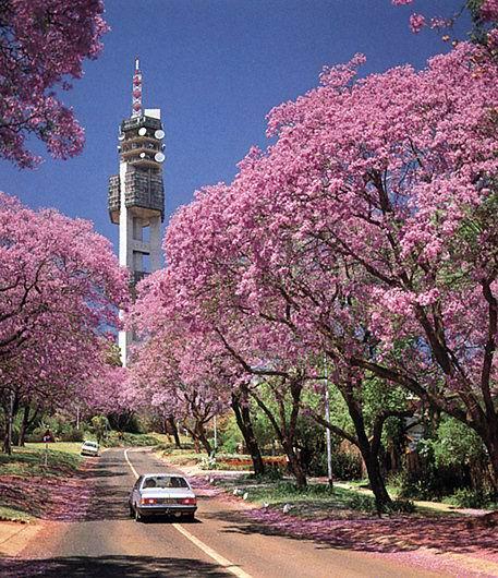
SOUTH AFRICA. Blooming jacaranda trees.
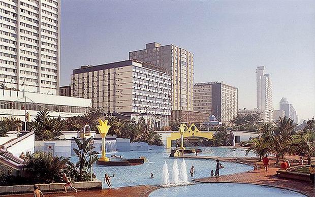
sun city
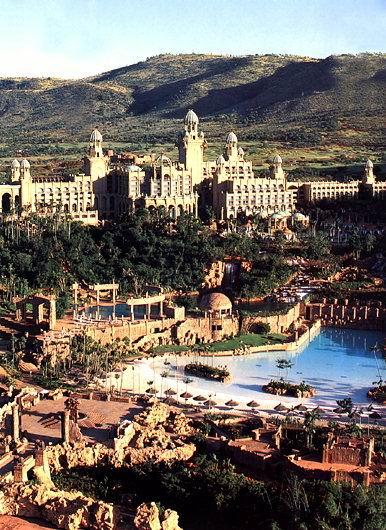
SOUTH AFRICA. Palace hotel in Sun City.
Two hours from Pretoria is Sun City, the most enchanting place in the Transvaal province and one of the finest and richest resort complexes in the world. It is famous for its picturesque landscapes and landscapes, gaming halls, nightclubs and theaters, as well as 4 spacious hotels, one of which is the famous pyramidal Cascade. In the most remarkable part of Sun City, Lost City, the Palace Hotel is located - the most beautiful ensemble, consisting of towers and minarets, waterfalls and pools. The Palace Hotel has 350 luxurious rooms and a three-story grand entrance. Below - a "jungle" of more than 3,500 trees and a pool with artificial waves.
Mountainous regions of the Eastern Transvaal
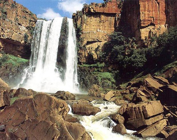
SOUTH AFRICA. Waterfall in the Dragon Mountains.
Few places in South Africa can match the Dragon Mountains in the Traansvaal (Transvaal Drakensberg) - an area of wooded slopes and high peaks, low green plains, tireless mountain streams and sparkling waterfalls. Beautiful waterfalls on the river Elandz in the southern foothills. In the rocks called Bourque's Blissful Potholes, one can only marvel at the whirlpool fantasies. One of the attractions of this area is a picturesque place with the poetic name of the Pilgrims' Rest, where there used to be one of the gold mines, and now it is a "living museum". The village is preserved in the form it was in the period from 1880-1915.
Blyde River Canyon is a magnificent red sandstone gorge that looks great from the massive Maripskop and Three Rondavel plateaus. One of the most spectacular viewpoints on the Panorama Trail is God's Window, which offers breathtaking views of the Lowveld Valley and Mozambique. The Blyde River forms a beautiful dam lake in the gorge, a transparent and reflective body of water inhabited by hippos and crocodiles. Mount Sheba Hotel is located in the mountains in an ecologically clean forest area - several beautiful buildings in the midst of charming nature.
Kruger park
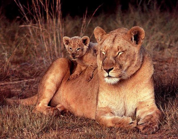
SOUTH AFRICA. Lions in Kruger Park.
National Kruger Park occupies almost 20 thousand square kilometers in the Lowveld region to the east of the Transval Drakensberg. This reserve can literally be called a paradise for many species of African wildlife. Among them are 137 species of mammals, but most of all lions, African wild boar, arrogant giraffes. Beyond the park's western boundary are three of the world's largest private wildlife sanctuaries, with exceptional and exceptionally comfortable camps staffed by professionals with excellent knowledge of animal life. These are the reserves of Ingvelela, Mala Mala and Londolozi. Mala Mala is famous for the largest concentration of large species.
dragon mountains
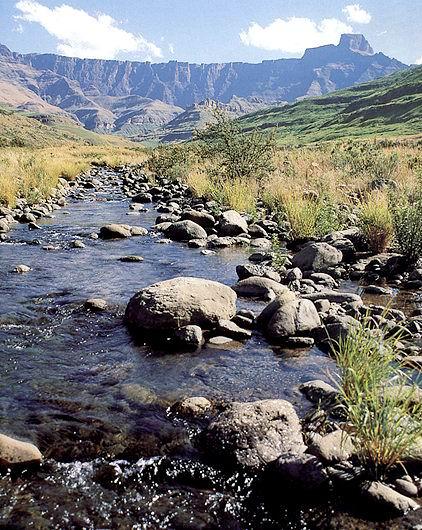
SOUTH AFRICA. Tugela river.
The heights of the main Drakensberg mountain range are stunning with their views, with slopes descending almost vertically by 2 thousand meters to the busy heights of Natal. The mountains are surrounded by foothills, considered a Mecca for anglers. The Tugela River is one of several that originate in a mountain range called the Amphitheater because of its flat top.
SOUTH AFRICA. Durban.
Durban is the third largest city in South Africa, its leading seaport and one of the most popular holiday destinations. Among the attractions of Durban are a beautiful natural bay, beautiful spacious beaches and a wonderful six-kilometer seaside boulevard called the Golden Mile. Many of the inhabitants of Durban are of Indian origin.
Inland part of the country of the province of Natal
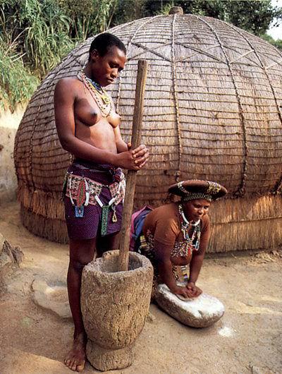
SOUTH AFRICA. Zulu women.
The most picturesque place between the Natal Drakensberg and the Indian Ocean in the east of the province is the Hovik waterfalls, amazing water cascades falling from a height of 95 m into the Mgeni River. The Midmar Dam and Nature Reserve are nearby.
Land of the people of Kos
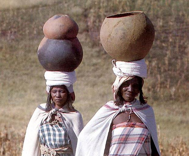
SOUTH AFRICA. Xhosa women.
Between the province of Natal and the Eastern Cape is the Transkei region, where the indigenous people of South Africa live - the Xhosa people. It is also the land of rivers, winding green hills, and a beautiful coastal strip known as the Wild Coast. In some places, ocean waves make "holes" in the coastal hills and rocks.
park way
The park path extends along the southern cape from the Stroms River to Mossel Bay. This path runs along a fabulous coastal terrace, touching the sea on one side and the mountains on the other. A narrow throat connects the sea with the 17 km Knysna lagoon. The lagoon is surrounded by sand cliffs with the poetic name of The Heads. Knysna is connected to the mainland small town of George by a single-track railway bridge over which steam locomotives smoke.
Between the Knysna lagoon and the Wilderness there are several large and beautiful straits where waterfowl live. This is the region of the Lakes, the center of which is the Touse River. The Knysna-Tsitsikamma area is famous for its forest thickets. Unique in these forests is the yellow Outeniqua tree, called the Big Tree. At the northern end of the Parkway, between the coastal rampart and the Swartberg mountain range, is a dry, but famous for its agriculture and pastoralism area called the Little Karoo, famous for the Kango Cave. On the other side of Swartberg, on the edge of the Great Karoo, is the Valley of Solitude, with windswept basalt rock formations.
Cape Town - the father of cities
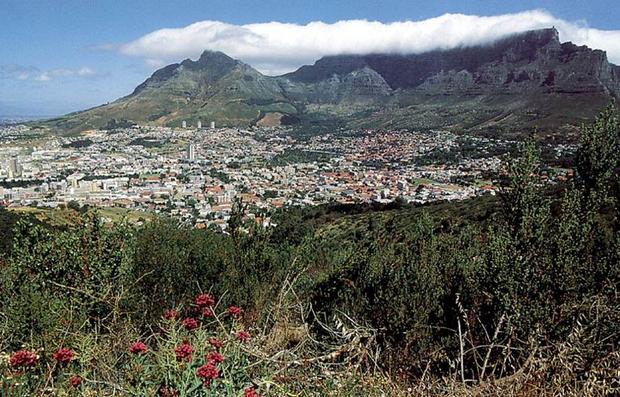
SOUTH AFRICA. View of Cape Town.
The very first city of South Africa - Cape Town - is comfortably located at the bottom of the plateau of Mount Table (lit. "table"), one of the most wonderful places on the planet. Competing with Table Mountain is only the port and waterfront of Cape Town, home to a kaleidoscope of bistros, bars, specialty shops and museums.
Cape Town. View of the city from the ocean.
Cape Peninsula
On the coast of the Cape Peninsula there are a huge number of first-class beaches. The wide, white-sand shores of Clifton are washed by the Atlantic Ocean from the west. The east coast of Fish Hex is washed by the warm waters of Falls Bay. At the extreme point of the peninsula is Cape Point, a large ridge that cuts into the sea and part of the Cape of Good Hope Nature Reserve. It was at this cape that the appearance of the “Flying Dutchman”, a vision ship, doomed to sail the seas until the Day of Judgment, was recorded in writing.
Hout Bay forms a wonderful bay where one of the nicest coastal villages is located, nestled in a wide green valley surrounded by picturesque hills. From here, a road runs south along the coast through steep cliffs under the mountain top of Chapman's Peak, which offers stunning views of the bay and cliffs. On the "Wine Route" that runs through the peninsula is the Groot Constantia estate, originally owned by Simon Van Der Stel, a prominent early ruler of the Cape, who lived there until his death in 1712. The countryside to the north and east of Cape Town is a wonderful combination of mountains and fertile valleys, historically interesting towns and hospitable Dutch estates, wine yards and fruitful orchards. This area is called the Wine Lands.
West Coast
The coastal strip stretching north from Cape Town is known for its dry and windy weather, is not densely populated and is barren of any vegetation for most of the year, except for a few short weeks of spring when it is covered in the famous carpet of wild flowers. Among the attractive little villages on the south coast is the village of Arniston, notable for its good hotel and charming old fishermen's cottages. The southernmost point of the African continent is Cape Agulas, where an outwardly unattractive, but very charming lighthouse is located.
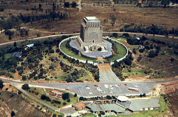
Pretoria. Monument "Great Migration" (Eng. Great Trek, Afrikaner. Voortrekker). Opened in 1949 in memory of the first Afrikaner settlers.
